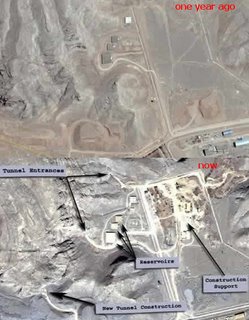
New satellite imagery indicate Iran has expanded its uranium conversion site at Isfahan and reinforced its Natanz underground uranium enrichment plant against possible military strikes.
Iran last week announced it had enriched uranium for use in fuelling power stations for the first time, stoking a diplomatic crisis over Western suspicions of a covert Iranian atomic bomb project. Iran says it seeks only nuclear energy for its economy.
(Reuters)
Isfahan is the place where uranium is first processed and where a storage facility is being built. You can compare how it looked a year ago and how it looks now using Google Earth. You just need to import a KMZ file.
More: Ogle Earth


